Archived material Access restricted Article
Rantburg

Today's Front Page   View All of Tue 02/19/2008 View Mon 02/18/2008 View Sun 02/17/2008 View Sat 02/16/2008 View Fri 02/15/2008 View Thu 02/14/2008 View Wed 02/13/2008
1
2008-02-19 Home Front: WoT
Navy to shoot down failed satellite Thursday
Archived material is restricted to Rantburg regulars and members. If you need access email fred.pruitt=at=gmail.com with your nick to be added to the members list. There is no charge to join Rantburg as a member.
Posted by Steve White 2008-02-19 00:00|| || Front Page|| [8 views ]  Top

#1 Oh, goody! Things that go BOOM! and are magical. Because electronics is nothing but magic! Pure F&%#*ing Magic!
Posted by AlmostAnonymous5839">AlmostAnonymous5839  2008-02-19 00:09||   2008-02-19 00:09|| Front Page Top

#2 Is there anything the SM-3 can't do?
Posted by gromky 2008-02-19 00:14||   2008-02-19 00:14|| Front Page Top

#3 C2CAM Website > DANGER ROOM/WIRED.com > INSIDE AMERICA'S SATELLITE-KILLING MISSLE. AEGIS SM-3's have a dangerous weakness vv guidance control system cracks, plus a lack of realistic HIGHER-ALTITUDE testing for this kind of mission. ARTICLE - MISSLE "CAN'T HIT WHAT IT CAN'T SEE".

*OTOH, "IF IT MISSES, NOTHING CHANGES". Famous last words - remember this vv RELIABLE PLANETARY DEFENSE? = DATA MGT? when the world sees MOON EXPLOSIONS come 2030, KAMALEN, plus any and all space events after 2010. REMEMBER, TU24 WAS SUPPOSED TO PASS EARTH AS A SINGLE, SAFE, ORGANIZED/UNIFIED OBJECT, AND WAS NOT SUPPOS TO HAVE FIREBALLS BEFORE AND DURING ITS PASSAGE [Fragments?]. NASA-JPL in 2008 = OWG in 2030, STARFLEET or SUPREME HEADQUARTERS, ASTEROID/ALIEN DEFENSE ORGANIZATION, etc? has yet to explain the fireballs nor other observed space boom-booms that occurred.

D *** NG IT, OWG MADONNA FANS OF AMERIKA/USSA DEMAND PERFECT PLANETARY DEFENSE AND ASTEROID MANAGEMENT, SPACE ROCKS CAN'T BE TRUSTED - SPOCK LOST HIS BRAIN, AND CAPTAIN KIRK TURNED INJUN!
Hmmmmm, now that I think of it, what happened to SPock, Kirk involved SPACE ROCK SPACE BABES > MMMMMUUUULLLLTTIIPPAAAAASSSSSS.......DON'T DATE ROBOTS!
Posted by JosephMendiola 2008-02-19 00:48||   2008-02-19 00:48|| Front Page Top

#4 "Okay, gents, we are go for launch. One more quick check. Do the Russkies have their binoculars up?"

"Aye aye, sir, yes indeed they do."

"How 'bout the ChiComs?"

"Affirmative, sir."

"And Short Round?"

"Sir, they got him a box to stand on and he's looking through the telescope now."

"Last check...what's the status in Saudi?"

"Unclear, sir. King Abdullah's been in a meeting all morning with the moon-sighting committee and the Minister for Science and Issuing Fatwas."

"Very well, then...you may fire for effect."
Posted by Seafarious 2008-02-19 00:56||   2008-02-19 00:56|| Front Page Top

#5 Although the animations on tv show an evening or night launch, does anyone know yet if that will be the case? A night detonation should look pretty decent up there, and the closer we get to TMinus, the navy may let everyone know where the first intercept will be. I would assume the Interceptor will have a proximity homing trigger for contact, but if it misses, will the missile continue on into space with it's escape velocity unarmed or fall back to Earth unarmed? Any thoughts?
Posted by smn 2008-02-19 03:02||   2008-02-19 03:02|| Front Page Top

#6 The Space Shuttle solid rocket boosters separate at about 30 miles up, and fall back, I've learned, but not sure if gravity would pull back accelerating thrust projectile at 150 miles?? I guess it depends on the vector!
Posted by smn 2008-02-19 03:16||   2008-02-19 03:16|| Front Page Top

#7 Because electronics is nothing but magic! Pure F&%#*ing Magic!

That's the first thing we were taught in Tech School. All electronics are FM, F&%#*ing Magic.
Posted by Steve 2008-02-19 07:48||   2008-02-19 07:48|| Front Page Top

#8 That's odd, why is my post all in italics? More FM I guess.
Posted by Steve 2008-02-19 07:51||   2008-02-19 07:51|| Front Page Top

#9 First live test of the intercept system.

Pay attention Iran and China.
Posted by DarthVader">DarthVader  2008-02-19 09:33||   2008-02-19 09:33|| Front Page Top

#10 If it works, and it should, it will be a pretty big deal. Still, the critics will say:

1) The defunct satellite was just loping along compared to an ICBM warhead package.

2) Said satellite is the size of a Greyhound bus, while a MIRV bus is about the size of a Hummer.
Posted by M. Murcek">M. Murcek  2008-02-19 10:00||   2008-02-19 10:00|| Front Page Top

#11 They are taking it out probably in one of the 3 orbits that take it over the west coast of the US near sunset. A hit there would ensure that it happened away from the US mainland, but close enough to be captured by ground based instruments that will be very valuable in judging how well the SM-3 and the Aegis targeting system worked

Those of you on the left coast oughta get a nice light show if they hit that 50Kg tank of Hyrazine. 246Km alt or close to that (Pretty sure its approaching perigee)

For those of you able to understand how to calc astronomical coordinates, this site has a very nice coordinate and pointing system that does the calcs for you, and will even estimate the brightness, etc. Just punch in the date of 21 Feb 2008 1800 PST (convert to whatever your time zone is). Usually by your IP it will guess the proper timezone.

Its near civil twilight o the west coast (just below the horizon), so it should be a slightly darker sky, and the satellite itself is still very much in sunlight and well above the local horizon, so it should be a a spottable little bugger with the right gear and pointing instructions.

For example, if you were in San diego, the satellite will be 11 magnitude when it appears over the horizon to the west (260 degrees) and will travel in an arc across the lower part of the north western quadrant of the sky, until it passes out of sight below the northern horizon just a bit past due north (9 degrees) at magnitude 5. It will be 1800Km away at the ends, and about 1000Km away at mid point in the visible part of its orbit (which is likely when the shot will be taken). Once its out of sunlight it will not be visible using purely optical means.

Remember this is roughtly a 5x10 meter object so its tiny up there in space 1000-2000km away. Suffice to say you will need a telescope.

If the Navy does its job it should get VERY bright for a fraction of a second.

San Fran on the coast (not in the city - light pollution) will get a very good view of it as it goes staight overhead on that orbit, as will non-urban coastal areas to the south and north (except where the line of sight crosses an urban area).

Folks in Idoaho, N Utah, Montana and North Dakota should be the first to spot the initial debris as it burns up on reentry. Pretty sparsely populated areas too, on up into Canada then the N Atlantic on down to western africa and the bulk of the remaining orbit over nothign but oceans and off the SE part of Australia - good calculation by the BMD guys for that entry footprint.

Probably take a few orbits to completely decay out all the larger fragments, and about 20 to completely clear everything except a few "nuts and blots" type of fragments, depending on what kind of vector the explosion imparts on said fragments.

OH, and the reason I posted it here is that I didnt want to steal the guy's bandwith by putting it on the front page.

However, feel free to copy it local bandwidth and do a post of the above for the Rantburg U's Astronomy and BMD Class.

FYI - NOTAMS are already out for this.
Posted by OldSpook 2008-02-19 10:35||   2008-02-19 10:35|| Front Page Top

#12 Cruiser will be someplace off S Alaska. - allows it to grab the satellitle at an off angle. seeker warheard will have a good angle on the targte, the night side will be behind it and it will still be sunlit from one side, making it a very bright object (relatively speaking),

5m x 10m is the nominal target size.
Posted by OldSpook 2008-02-19 10:37||   2008-02-19 10:37|| Front Page Top

#13 Very interesting, OS. Us right coast folk will just have to use our imaginations, I s'pose.
Posted by Seafarious 2008-02-19 12:08||   2008-02-19 12:08|| Front Page Top

#14 OldSpook, is the platform going to be a cruiser? Not a Burke Class destroyer?
Posted by M. Murcek">M. Murcek  2008-02-19 12:18||   2008-02-19 12:18|| Front Page Top

#15 I'm hoping for some unclassified pics of a nice contact after this happens.

Do the Arleigh Burkes even carry the newer SM3?

You know, I would have thought this would be perfect for a THAAD intercept. My guess is that they've got the land based platforms issues worked out pretty well and are working on the sea-based ones?
Posted by Anon4021 2008-02-19 12:25||   2008-02-19 12:25|| Front Page Top

#16 Said satellite is the size of a Greyhound bus

I assume this is with solar panels deployed, not folded as they may be now if the satellite failed due to lack of power.
Posted by gorb 2008-02-19 12:47||   2008-02-19 12:47|| Front Page Top

#17 The Cruiser/Destroyer lines have become blurred in terms of capability these days.
Posted by OldSpook 2008-02-19 13:49||   2008-02-19 13:49|| Front Page Top

#18 But is its the USS Lake Erie (CG-70), a Baseline 4 Ticondergoa class. Radars and software are the upgraded version of whats on the Burkes. She's been refitted as probably the primary SMD-BMDS/KW testbed ship in the Navy.
Posted by OldSpook 2008-02-19 14:19||   2008-02-19 14:19|| Front Page Top

#19 FYI - The main target is the hydrazine in a beryllium-lined fuel tank. Someone told me my 50kg estimate was wrong, that there is actually 1,000 pounds in there. It uses a surface screen catalyst (a very fine mesh of alumina and molybdenum coating), not a separate fuel mixture for the ignition reactions. Thats for the orbital maneuvering system. This satellite must have been completely crippled if they couldn't even send it commands to vent the tank.

Posted by OldSpook 2008-02-19 14:27||   2008-02-19 14:27|| Front Page Top

#20 Symptoms of acute exposure to high levels of hydrazine include irritation of the eyes, nose, and throat, temporary blindness, dizziness, headache, nausea, pulmonary edema, seizures, and coma in humans. Acute exposure can also damage the liver, kidneys, and the central nervous system (CNS) in humans.

The liquid is corrosive and may produce chemical burns and severe dermatitis from skin contact.

Acute animal tests in rats, mice, rabbits, and guinea pigs have demonstrated hydrazine to have high acute toxicity from inhalation and ingestion and extreme acute toxicity from dermal exposure.

http://www.epa.gov/ttn/atw/hlthef/hydrazin.html
Posted by OldSpook 2008-02-19 14:31||   2008-02-19 14:31|| Front Page Top

#21 Anon 4021, the reason using an SM3 is the geometry is wrong for the land based stuff. Go lock at the orbital tracks - the come up out of the south pacific and cruise up north over Canada. Much mor of a polar inclination, and also more than 90 degrees off angle from what a korean or shinese. launch would be (coming from the southwest instead of the northwest)
Posted by OldSpook 2008-02-19 14:34||   2008-02-19 14:34|| Front Page Top

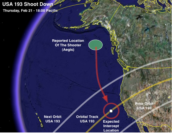
#22 Impact in the red circle (picture below) would ensure that it happened away from the US mainland, but close enough to be captured by ground based instruments that will be very valuable in judging how well the SM-3 and the Aegis targeting system worked


Open Source credit goes to this site.
Posted by OldSpook 2008-02-19 14:40||   2008-02-19 14:40|| Front Page Top

#23 'Spook, thanks for all the details. You are a prince among men.
Posted by Mike 2008-02-19 14:47||   2008-02-19 14:47|| Front Page Top

#24 Odd, I thought there were THAAD units in Alaska.

That's an informative pic, thanks OldSpook.
Posted by Anon4021 2008-02-19 14:57||   2008-02-19 14:57|| Front Page Top

#25 A successful intercept with the SM-3 would say we can position this sea-based system any damn place we choose, to defend our assets and allies around the world and not just CONUS.

A useful message, methinks.
Posted by lotp 2008-02-19 15:11||   2008-02-19 15:11|| Front Page Top

#26 Looking at that map I am left to hope wonder, will the probable impact point for any debris be Berkeley?
Posted by Nimble Spemble 2008-02-19 15:17||   2008-02-19 15:17|| Front Page Top

#27 CNN nows says Weds shootdown.
Posted by 3dc 2008-02-19 15:37||   2008-02-19 15:37|| Front Page Top

#28 US Warships Moving into Position for Satellite Shootdown
Posted by lotp 2008-02-19 16:48||   2008-02-19 16:48|| Front Page Top

#29 If its Wednesday then it will not be as easy to observe. Orbit must b e decaying a bit more rapidly.

And that picture tells you why the THAADs in Alaska are out - they are oriented the wrong way - they are set for a different threat direction, and the intercept geometry is simply not good (their optiomal launch paths run almost parallel to the statellite tracks).

Thats the advantage of ship based BMD - they can move and get a better angle based on threat detection.
Posted by OldSpook 2008-02-19 16:59||   2008-02-19 16:59|| Front Page Top

#30 The angles are counterintuitive unless you know spherical geometry and orbital mechanics (especially relative orbital motions and the earth's rotation). The math ain't easy. That's why they call it Rocket Science.

New NOTAMS: 0230 UTC Thursday to 0530 UTC

Thats 1830-2130 PST Wednesday 20 FEB.

track data All times PST

1830 - over west africa
1845 - east coast of South Africa
1900 - just off the antarctic coast mid way between Oz and Africa
1915 - E of Oz N of NZ
1930 - over Pacific
1935 - off the West Coast, past the night time terminator but still illuminated and visible.

Thats my bet right there 1935 PST. Lat 211°29'54" +39°36'34" Lon, alt 246 Km.

The shots will be further south than the picture above. If its visible it will be from San Diego, with smaller debris, if any is left, coming in visible across CA, Nevada, Utah, Wyoming


Posted by OldSpook 2008-02-19 17:23||   2008-02-19 17:23|| Front Page Top

#31 Looking again, probably nothing will be visible from the west coast. It will be too far, and probably over the horizon
Posted by OldSpook 2008-02-19 17:25||   2008-02-19 17:25|| Front Page Top

#32 If they had to move the shoot back, I'd bet its due to due to orbital decay - the shots I outlined above are much more optimal for getting optical and radar instrumentation on everything (from the coast of CA, etc, and some of the OTH stuff in Alaska).

If that's the case then it will be from the area NE of Hawaii.
Posted by OldSpook 2008-02-19 17:29||   2008-02-19 17:29|| Front Page Top

#33 If the Air Force had any flash, they would just zoom over to the wayward satellite and pluck it from the sky. Leave it to the Navy to do the heavy lifting, he said, dousing himself with Inter-Service Rivalry brand gasoline.

Fascinating details, OS!
Posted by SteveS 2008-02-19 17:56||   2008-02-19 17:56|| Front Page Top

#34 Absolutely, Steve. USAF ret Mr. Lotp agrees -- kick the tires and light the fires on those interceptor jets!

What do you mean, we don't have jets that operate at an altitude of 150 nautical miles where there's essentially no atmosphere???

How about at 65 miles, where the satellite will begin burning up? Not there either???

hmph.

LOL
Posted by lotp 2008-02-19 18:03||   2008-02-19 18:03|| Front Page Top

#35 YAHOO NEWS > Shootdown may occur this Wednesday night instead of Thursday.

HOWZABOUT AFTER MIDNITE WEDNESDAY MORNING [Guam time] > two fiery surface-to-air thingys wid rocket tails were visually spotted taking off from the direction of northern Guam, blasting off straight up and then angling to only-God-knows-where into the cloud bands. TWAS RAINING + HEAVY DOWNCAST > looks like the USAF-DOD used the lousy weather as opportunity to conduct a COVERT TEST/MISSLES LAUNCH from Andersen AFB since nothing was announced in the local medias??? SPACE SHUTTLE TARGET TEST???
Posted by JosephMendiola 2008-02-19 18:18||   2008-02-19 18:18|| Front Page Top

#36 If they hit during the lunar eclipse, how spectacular would it be!!!!
Posted by Seafarious 2008-02-19 19:04||   2008-02-19 19:04|| Front Page Top

#37 LUCIANNE > US DECLARES 1400-MILE [by 700 miles] SAT-SHOOT EXCLUSION ZONE, in Northern Pacific area.

Also from LUCIANNE > METEOR STREAKS ACROSS THE EARLY MORNING SKY.
Posted by JosephMendiola 2008-02-19 19:24||   2008-02-19 19:24|| Front Page Top

#38 I believe the Aegis cruisers are the only US ships what currently are outfitted with the SM-3. Nothing prevents the destroyers from also deploying the SM-3 (Japanese Aegis destroyers) other than cost and a desire to stick to anti-air duties. Both the cruisers' and destroyers' radars and computers are being upgraded to track ballistic missiles.

What's interesting, other than vastly understating SM-3 range, is that if the Aegis and SM-3 can intercept a satellite going 17,000mph, it can also intercept ICBMs during decent. Or by increasing missile size (Mk-41 VLS can launch 21 diam. missiles) it has a good chance of knocking down SLBMs/ICBMs in midcourse, esp. the new Russian ICBMs with fast burn motors and lower trajectories (1000km height).
Posted by ed 2008-02-19 20:48||   2008-02-19 20:48|| Front Page Top

#39 Hey Old Spook and all Rantburgers - is there any chance we could have Rantburgers on OS suggestions to keep an eye to sky tomorrow night and post if they see anything? Could be our first RB live intel session.... Just an idea and not sure if it is plausible.

Thanks again for the great info OS - love learning this stuff!
Posted by Yosemite Sam 2008-02-19 20:48||   2008-02-19 20:48|| Front Page Top

#40 I bet every amateur astronomer, and some no so amateur, will be trying to track that satellite tomorrow.
Posted by ed 2008-02-19 20:54||   2008-02-19 20:54|| Front Page Top

#41 People in Hawaii are likely to have the best eyeball on it - look N and E about 30 degrees above the horizon at 0335 UTC. Luckily you will be looking away from the setting sun and into the evening sky.

And Joe, yes - I updated iti with the NOTAMS data. 1830-2130 Pacific Time tomorrow night.

likely time for west coast is 1935 local in the SW sky. If its later than that it will be over the howrison to the west if they want to do visual/optical observation (it gets eclipsed on subsequent orbits furhter west and later).


Mods - you may want to contue this thread into tomorrow so we dont lose the data.

Posted by OldSpook 2008-02-19 21:26||   2008-02-19 21:26|| Front Page Top

#42 FYI the nominal speed is now 7Km/s (15658 mph)

In short its slowing down a lot.
Posted by OldSpook 2008-02-19 21:32||   2008-02-19 21:32|| Front Page Top

#43 West Coast = mucho cloud cover and rain...no visuals likely, but Will notarized and catchers' mitt (and cup) ready. I'll need a snort or two for corage, but standing in position! Back to RBHQ!
Posted by Frank G">Frank G  2008-02-19 23:02||   2008-02-19 23:02|| Front Page Top

#44 I've scoped in my deer rifle.
Posted by www 2008-02-19 23:04||   2008-02-19 23:04|| Front Page Top

#45 Do you think you'll be able to out-shoot the navy with that, www? ;-)
Posted by trailing wife ">trailing wife  2008-02-19 23:48||   2008-02-19 23:48|| Front Page Top

23:48 trailing wife
23:40 Anonymoose
23:32 Anonymoose
23:16 Alaska Paul
23:04 www
23:02 Frank G
22:43 OldSpook
22:41 RD
22:36 OldSpook
22:30 OldSpook
22:24 FOTSGreg
22:22 trailing wife
22:18 trailing wife
22:11 trailing wife
22:08 trailing wife
22:05 trailing wife
22:04 Old Patriot
22:04 49 Pan
22:03 trailing wife
22:01 Frank G
21:48 E Brown
21:47 trailing wife
21:47 Redneck Jim
21:42 Steven


Paypal:
Google
Search WWW Search rantburg.com